 The Backyard Brewhouse - Gatehouse
Trading Estate, Lichfield Road,
The Backyard Brewhouse - Gatehouse
Trading Estate, Lichfield Road,maps.google.co.uk pointer - 52.651604, -1.920011
Web site --- http://thebackyardbrewhouse.com/
(Entry updated 1/10/2012)
Brownhills Pubs
The Public Houses of Brownhills (and a brewery or two!)
In the West Midlands of England.
The Backyard Brewhouse - Gatehouse
Trading Estate, Lichfield Road,
maps.google.co.uk pointer - 52.651604, -1.920011
Web site --- http://thebackyardbrewhouse.com/
(Entry updated 1/10/2012)
"The Backyard Brewhouse is, in traditional terms, a micro
brewery. We prefer to consider ourselves a small scale craft
brewery, dedicated to the production of only the finest quality
beers and ales."
The Brewery (established in 2008) sells direct to the public
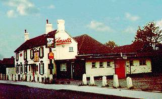
 Beowulf Brewing Company - Forest of Mercia -
Chasewater Country Park, Pool Road
Beowulf Brewing Company - Forest of Mercia -
Chasewater Country Park, Pool Road
maps.google.co.uk pointer - 52.661223,
-1.942445
Web site --- http://www.beowulfbrewery.com/
(Entry updated 1/10/2012)
This company marked the return to Brownhills of brewing a
century after the glory days of the Station Hotel based
brewing empire of William Roberts.
Originally established in Birmingham in 1997 the Beowulf Brewery
microbrewery moved to Brownhills in 2003 and produce a range of
specialist ales. The "Real Ale" can be found as a
regular or guest beer at some of the pubs of Brownhills and in
the surrounding area.
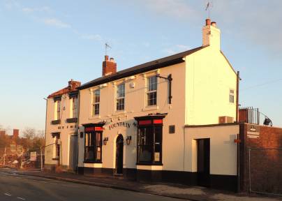 The
Fountain Inn - 49 Lower Forster Street, Walsall
The
Fountain Inn - 49 Lower Forster Street, Walsall
maps.google.co.uk pointer - 52.588019,-1.978118
Web site --- http://www.walsallpubfood.com/
-- but note that this may not be up to date.
(Entry updated 28/1/2013)
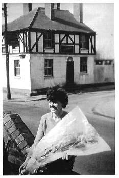
Not a pub in Brownhills but the Brownhills brewery The Backyard Brewhouse have their first pub.
From http://thebackyardbrewhouse.com/news "Our Latest Project ......... the newly refurbished Fountain Inn, Lower Forster Street, Walsall. The pub had been closed since August 2011 and nearly met an untimely end when the neighbouring Jabez Cliff factory burned down. Fortunately the pub survived and was acquired by the Backyard in early November this year(2012). The pub will be run by local, popular character John Horton. Formally a sign writer for Highgate brewery and previous manager of ‘The Pretty Bricks’, (another popular Walsall pub), we have high hopes for this ever popular local pub."
(photo 14/1/2013)
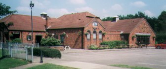
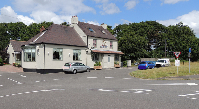
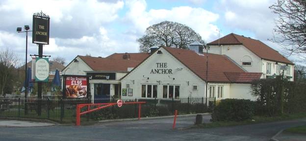 The Anchor (previously
"the Anchor Inn" and "the Old Anchor Inn" )
on the Chester Road, opposite the start of Lindon Road.
The Anchor (previously
"the Anchor Inn" and "the Old Anchor Inn" )
on the Chester Road, opposite the start of Lindon Road.
maps.google.co.uk pointer - 52.640980, -1.923678
Web site --- http://www.anchorinnpubwalsall.co.uk/
(Entry updated 1/10/2012)
The current building dates from 1986.
To the left of the picture is the canal which gave rise to the pub's name. The previous pub on the site had stables for the canal horses.
A pub has been on the site from the time of the Wyrley and Essington Canal when the Anchor bridge was built in 1797 to carry the "Old Chester Turnpike Road" over the canal.
(photo 10/4/2006)
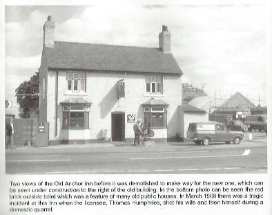 The photograph on
the left was taken before the Anchor's refurbishment of 2002.
The photograph on
the left was taken before the Anchor's refurbishment of 2002.
(photo 2002)
The photograph on the right was taken
shortly before the old Anchor's demolition.
The current pub can be seen under construction on the right-hand
background.
From Memories of Brownhills Past by Clarice Mayo & Geoff Harrington. Published 2003
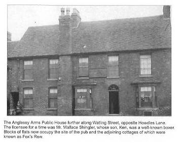 The
Anglesey Arms, 83 Watling Street.
The
Anglesey Arms, 83 Watling Street.
maps.google.co.uk pointer - 52.656088, -1.931646
The pub stood opposite Howdles Lane on what is now a patch of grass adjacent to a (now demolished) block of flats on the corner of Deakin Avenue. The Anglesey Arms (part of a terrace of dwellings called "Foxes Row") opened in about 1855.
(photo
on the left from
Memories of Old Brownhills by Clarice Mayo &
Geoff Harrington. Published in 2001)
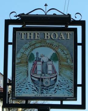 The Boat
- Walsall Road (A461), Summerhill, Nr Muckley Corner
The Boat
- Walsall Road (A461), Summerhill, Nr Muckley Corner
maps.google.co.uk pointer - 52.651851, -1.889412
Web site --- http://www.oddfellowsintheboat.com/index.php
(Entry updated 31/7/2015)
Now known as a "Oddfellows in the Boat"
On Walsall Road (the A461) between the Shire Oak Hill and Muckley Corner.
To the right of the picture is the path to the now long dry canal - currently being developed as a Heritage Towpath Trail.
When known as "The Old Boat Inn" - sold Blencowe's Ales.
(Photograph - 30 July 2015)
(More Photos in my Flickr album - The Public Houses of
Brownhills)
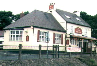 The Boat in 2000
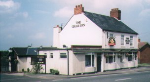 The Chase Inn on the Watling
Street, Newtown with the railway line at the rear.
The Chase Inn on the Watling
Street, Newtown with the railway line at the rear.
maps.google.co.uk pointer - 52.656231, -1.920118
Web site --- https://www.facebook.com/TheChaseA5?fref=ts
(Entry updated 31/7/2015)
Dating from at least 1857.
Chester's Wine Bar - see Simply Blues
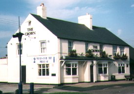 The Crown, 196 Watling Street
at the junction with the Chester Road. Was known to exist in 1880.
The Crown, 196 Watling Street
at the junction with the Chester Road. Was known to exist in 1880.
maps.google.co.uk pointer - 52.656205,
-1.951543
Web site --- http://www.crownpubbrownhills.co.uk/
(Entry updated 1/10/2012)
"The Fortunes of War" - see The Pier Inn.
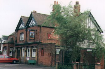 The George and Dragon,
Clayhanger. Now Clayhanger Village Community Centre.
The George and Dragon,
Clayhanger. Now Clayhanger Village Community Centre.
maps.google.co.uk pointer - 52.639278,
-1.940932
Web site --- https://sites.google.com/site/clayhangervillagecc/
(Entry updated 1/10/2012)
The current building is about 100 years old. A pub has been on the site from at least 1871.
"Hoofbeats" - see The Terrace.
"The Huntsman" - see "Smithys Forge".
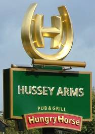
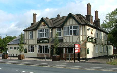 The Hussey Arms,
Chester Road. On the edge of the Common.
The Hussey Arms,
Chester Road. On the edge of the Common.
maps.google.co.uk pointer - 52.650478,
-1.938035
Web site --- http://www.hungryhorse.co.uk/index.php/pub-finder/details/?id=1671
(Entry updated 1/10/2012)
Reopened in August 2011 as a "Hungry Horse" house.
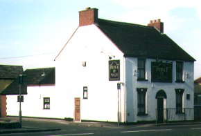
A Hussey Arms (previously the Hussey's Arms) has been on the site from the 1850's. Named after the Hussey family who were the landowning family of Wyrley Hall.
An earlier pub "The Turks Head" occupied the site until demolished due to subsidence.
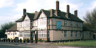 (photo 2002)
Before the pub was renovated and reopened as a Hungry Horse it
was "The New Hussey Arms & Spaghetti Factory".
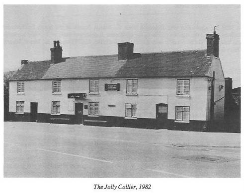 The
Jolly Collier (on the corner of Pelsall Road and Coppice
Road)
The
Jolly Collier (on the corner of Pelsall Road and Coppice
Road)
maps.google.co.uk pointer - 52.643845,
-1.948909
Built in the early 1800's. A stable block owned by the Wyrley and Essington Canal was at the rear adding canal workers to the coal miners of the area as early custommers. The pub was closed in 1982 and demolished in 1990. The site is now a carpark for T&S distibution company.
(photo on the left from
BROWNHILLS A Walk Into History With Gerald Reece by Gerald Reece,
Published by Walsall Local History Centre, 1996 - ISBN 0 946652
42 2)
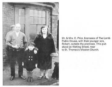
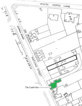 The Lamb Inn - 119 Watling Street
maps.google.co.uk pointer - 52.656205,
-1.936780
was on the north side of the street
about a hundred metres east of its junction with the Parade and
Whitehorse Road. The site is currently a grassed area between 114
and 120.
(photo on the left from
Memories of Old Brownhills by Clarice Mayo &
Geoff Harrington. Published in 2001)
The plan on the right has 119 highlighted in green
"Oddfellows in the Boat" - see The Boat.
 The Old
Leopard - Now a private dwelling......
The Old
Leopard - Now a private dwelling......
maps.google.co.uk pointer - 52.641074,
-1.908166
(Photo 16/2/2011)
The building is abutting to130 Lichfield Road, Sandhills - half a mile down from the Shire Oak crossroads towards Muckley Corner. It is about 100 metres past and opposite to Lanes Farm.
The name plate reads .......... “The Old Leopard Inn – C1750-1911”
"The Leopard" / "The Old Leopard" - the same? or two different buildings? Does anyone out there know any of the history of this old pub or pubs?
"The Monkey" - see "Ye Olde Wilkin Inn".
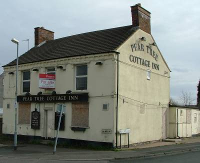
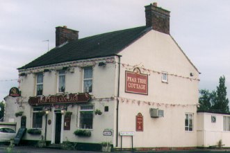 The Pear Tree Cottage
Inn at the junction of Hednesford Road,
Albutts Road and Pear Tree Lane.
The Pear Tree Cottage
Inn at the junction of Hednesford Road,
Albutts Road and Pear Tree Lane.
maps.google.co.uk pointer - 52.660643,
-1.952305
(Entry updated 1/10/2012)
After long-term closure the pub was demolished in the summer of 2012 and the site cleared for a proposed shop to be built on the site.
Dates back to at least 1851.
(Photo left Mar 2009)
(Photo right Aug 2000)
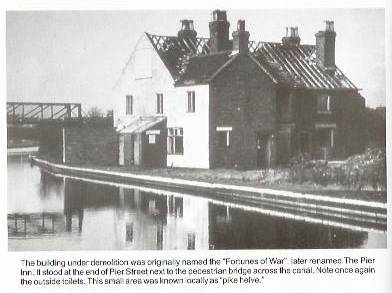 The
Pier Inn
The
Pier Inn
maps.google.co.uk pointer - 52.644652, -1.932896
stood at the end off Pier Street next to the "Spot" footbridge over the Wyrley and Essington Canal. It was demolished in the early 1960s. The Pier Inn was previously "The Fortunes of War" from at least 1870. Pier Street was named after the pier built into the canal for loading and unloading.
(photo on the left from
Memories of Brownhills Past by Clarice Mayo &
Geoff Harrington. Published 2003)
 The Prince of Wales, 98
Watling Street.
The Prince of Wales, 98
Watling Street.
maps.google.co.uk pointer - 52.656257, -1.934221
The book "Brownhills - a walk into
history" by Gerald Reece says....
(landlords)
1908 S Page
1914 WA Norris
1940 Mrs. Mary Prior
1986 Bob & Sue Greaves
Geoff & Jane Taylor September 2003 to August 2007 as a
free house
2007 ..... a Scottish & Newcastle Pub Company house
 The
Queens Head
The
Queens Head
maps.google.co.uk pointer - 52.656189, -1.929034
- was on the Watling Street at the corner of Castle Street (earlier known as "the Fault") from at least 1888 until its closure in 1966.
(photo on the left from
Memories of Brownhills Past by Clarice Mayo &
Geoff Harrington. Published 2003)
The photo shows Betty Brookes outside her shop with the
Queens Head in the background on the other side of Watling Street.
This was in the 1960's when the road was still a single
carrageway.
 |
The Railway Tavern At the
corner of Lichfield Road and Narrow Lane. maps.google.co.uk pointer - 52.649466, -1.930236 Previously "The Railway Inn" had occupied the site from the 1850's. Since the pub was demolished in October 1993 the site has been used for housing. |
| Copyright Acknowledged
- Brian Walker 1993 Taken just before demolition |
 The Red White and Blue,
Walsall Road (A461), Springhill, Nr Muckley Corner - Now a private dwelling "The Willows"......
The Red White and Blue,
Walsall Road (A461), Springhill, Nr Muckley Corner - Now a private dwelling "The Willows"......
maps.google.co.uk pointer - 52.644925, -1.900098
(Entry updated 5/4/2012)
(Photo 13/3/2012)
On Walsall Road (the A461) between the Shire Oak Hill and Muckley Corner
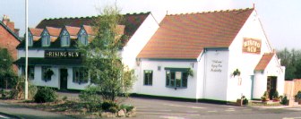 The Rising Sun,
Watling Street at the junction with the Chester Road.
The Rising Sun,
Watling Street at the junction with the Chester Road.
maps.google.co.uk pointer - 52.655984,
-1.952375
(Currently closed ---- Entry updated 4/9/2011)
(Photo left Mar 2009)
(Photo right Aug 2000)
There has been a "Rising Sun" pub since at least 1769 at the time of the "Old Chester Turnpike Road" horse-coach route.
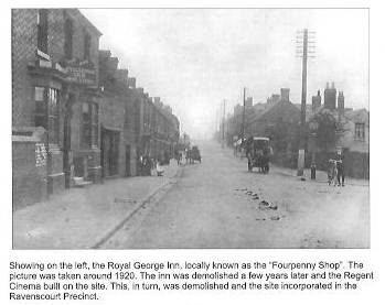 The
Royal George Inn
The
Royal George Inn
maps.google.co.uk pointer - 52.647252,
-1.933336
- built in the 1860s it was replaced in the 1928 by the Regent Cinema and that was, itself, replaced by the Ravenscourt shopping precinct in the 1966. The pub was the "Fourpenny Shop" to the locals.
(photo on the left from
Memories of Old Brownhills by Clarice Mayo &
Geoff Harrington. Published in 2001)
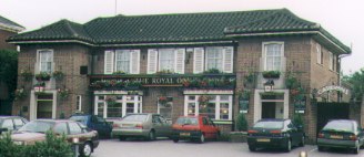
 The Royal Oak, Chester
Road (halfway up Shire Oak Hill)
The Royal Oak, Chester
Road (halfway up Shire Oak Hill)
(also known as "the middle oak").
maps.google.co.uk pointer - 52.638754,
-1.920140
Web site --- http://theroyaloakpub.co.uk/
(Entry updated 1/10/2012)
Known for it's 1930's Art Deco style. Voted the "Walsall
CAMRA Pub of the Year" in 1998 and 1999.
A previous pub of the same name was built in the mid 1800s.
(photo on the right from
Brownhills Local History Trail by Joyce Hammond,
Published by Walsall Library & Museum Services)
 The Shire Oak at the corner
of Chester Road and Lichfield Road. (also known as "the top
oak").
The Shire Oak at the corner
of Chester Road and Lichfield Road. (also known as "the top
oak").
maps.google.co.uk pointer - 52.635850,
-1.916905
The pub dates back to the mid 1800s.
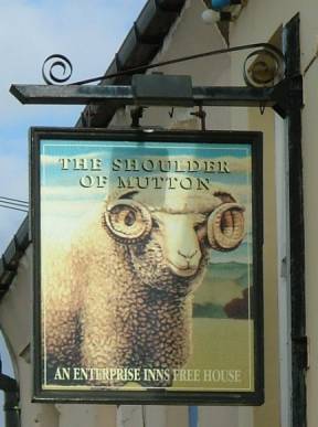
 The Shoulder of Mutton,
15 Church Road.
The Shoulder of Mutton,
15 Church Road.
maps.google.co.uk pointer - 52.647321,
-1.932650
(Photos 11/4/2008)
Still has some original William Roberts brewery windows.
The pub, dating from the mid 1800s, is reputed to take its name from the shape of the plot of land including a bowling green at the rear.
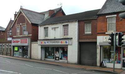 Simply Blues (previously
Chester's Wine Bar) 86 High Street
Simply Blues (previously
Chester's Wine Bar) 86 High Street
maps.google.co.uk pointer - 52.645680,
-1.931083
(Photo 16/2/2011)
(Trading as ECS Computers, WS8 6EW in 2011)
According to "BROWNHILLS A Walk Into History With Gerald Reece" by Gerald Reece, 1996 - page 51 ....
"Was George T. Roberts (wallpaper,
paint & builder’s merchant.
Became Chester's Wine Bar and Bistro.
June 1987 refurbished as Simply Blues (wine bar, bistro and
cocktail bar) ……"
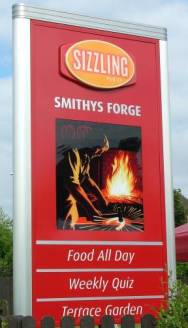
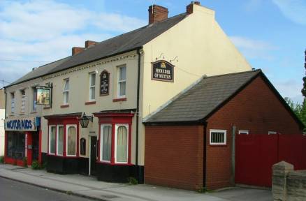
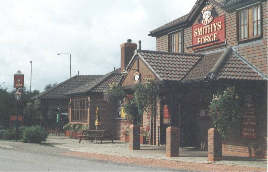 Smithys Forge, Lichfield Road.
maps.google.co.uk pointer - 52.648626,
-1.934216
Web site --- http://www.sizzlingpubs.co.uk/thesmithysforgebrownhills/
(Entry updated 4/9/2009)
(Photo Aug 2000)
Named after the blacksmiths that previously occupied the site (owned by the aptly named Mr. Smith).
The pub sign as a "Sizziling" house (Photo 11/4/2008)
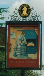 The pub sign when a Whitbread
house (Photo Aug 2000)
The pub sign when a Whitbread
house (Photo Aug 2000)
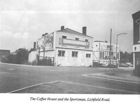 This site at the corner of High Street
and next to the (now closed) railway station has been a prime
spot for refreshment for as long as Brownhills could be called a
town. Brownhills Coffee House was opened in 1854 and later became
a Working Men's Club.
This site at the corner of High Street
and next to the (now closed) railway station has been a prime
spot for refreshment for as long as Brownhills could be called a
town. Brownhills Coffee House was opened in 1854 and later became
a Working Men's Club.
In 1958 the club moved to a larger building constructed at the rear - the original building was demolished in 1987.
In the 1960s the club closed and the new building became "The Huntsman" public house. This in turn became "The Sportsman" and was demolished in 1996 and has now been replaced by "Smithys Forge".
(photo on the left from
BROWNHILLS A Walk Into History With Gerald Reece by Gerald Reece,
Published by Walsall Local History Centre, 1996 - ISBN 0 946652
42 2)
"The Sportsman" - see "Smithys Forge".
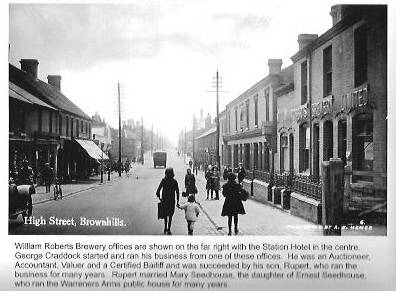
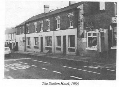 The Station Hotel, High
Street
The Station Hotel, High
Street
maps.google.co.uk pointer - 52.647829,
-1.934237
closed in 1983 and was demolished in 1990. The site is now
occupied by the Aldi supermarket.
William Roberts owned the Station Hotel from 1860 until his death
in 1906. His offices were to the right of the pub and his brewery
was at the rear of the pub.
He also owned the Royal George, Wheatsheaf, Warreners Arms, Swan Inn, Rising Sun and Shoulder of Mutton (where the etched glass windows still show his steam engine trade mark).
(photo on the left from
BROWNHILLS A Walk Into History With Gerald Reece by Gerald Reece,
Published by Walsall Local History Centre, 1996 - ISBN 0 946652
42 2)
(photo on the right from
Memories of Brownhills Past by Clarice Mayo &
Geoff Harrington. Published 2003)
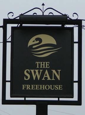
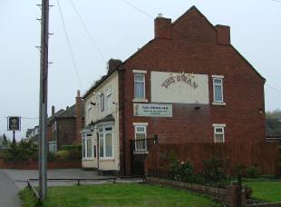 The Swan, Pelsall Road.
maps.google.co.uk pointer - 52.645853,
-1.942799
(Entry updated 22/11/2011)
(Photo left and right Nov 2011)
There has been a "Swan" in Pelsall Road from at least 1834. Also mentioned as "The Swan Inn", "The White Swan" and "The Red Swan".
Re-opened Saturday, 29th October 2011 ----- "The Swan Inn on Pelsall Road will be re-opening --- so come along and support ‘a true freehouse’. Geoff & Jane --- formerly owners of The Prince of Wales, Watling Street (2003 – 2007) have bought The Swan. Our ‘logo’, as one seems to need one these days, is ‘bringing the community together’. That is our aim and that is what we will strive to do. Now it will be a ‘true’ freehouse so you’ll be getting a better choice of brands at affordable prices. No hot food but cheese & onion / ham cobs (pork & stuffing cobs on Sundays), crisps, scratchings, nuts etc. We shall be on the lookout for darts, pool, cribbage, dominoes teams so, if you’re interested, come along and see us."
Check Facebook for details soon .....
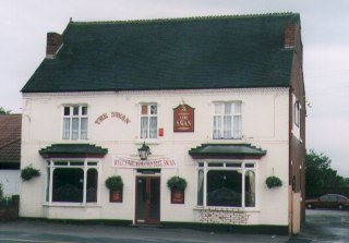 (Photo left Aug 2000)
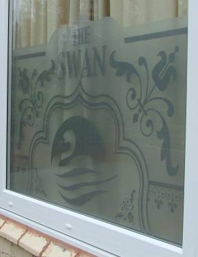
One of the new frosted glass
windows
(Photo right Nov 2011)
"The Turks Head" - see the Hussey Arms.
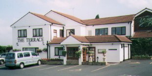 The Terrace, Watling Street,
Newtown . Now The Terrace Restaurant.
The Terrace, Watling Street,
Newtown . Now The Terrace Restaurant.
maps.google.co.uk pointer - 52.656069, -1.920826
Web site ---http://www.the-terrace-restaurant.co.uk/index.htm
(Entry updated 4/9/2009)
Was prevoiusly "Hoofbeats" restaurant from 1985 before being renamed the following year..Was once a service station with petrol pumps near the entrance - called "The Petrol and Pantry".
"Welsh Harp Inn" - (or Welsh
Harp)
maps.google.co.uk pointer - 52.656303, -1.931539
Recorded in 1743 this coaching inn was thought to be on the area of the current Howdles Lane shops, off Watling Street. Due to reduced passing traffic, the pub closed about 1790.
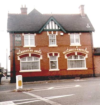
The Warreners Arms - converted
into a McDonald's burger bar which opened in 1999 and closed in
the middle of 2003.
maps.google.co.uk pointer - 52.642751,
-1.926572
Situated at 247 High Street on the corner of Ogley Road.
The Lord of the Manor of Norton (Richard Gilbert) introduced rabbits to the triangle of High Street, Ogley Road and Lichfield Road in 1765. It is beleved that the farm on the site and the following pub was named after the rabbit warrens of the area. Originally part of Warren House farm was used as a pub from the 1850s.
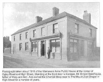 The earlier building on
the same site.
The earlier building on
the same site.
(photo on the left from
Memories of Old Brownhills by Clarice Mayo &
Geoff Harrington. Published in 2001)
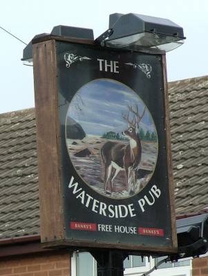
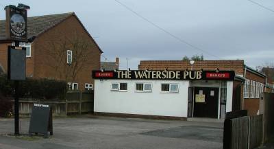 The
Waterside Public House - 42 Wilkin Road
The
Waterside Public House - 42 Wilkin Road
maps.google.co.uk pointer - 52.657923,
-1.950186
(Entry updated 4/9/2009)
(Photo left and right March 2009)
 Copyright Acknowledged - Brian Walker Taken just before demolition |
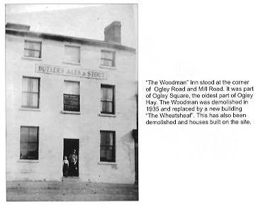
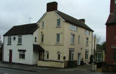
The Wheatsheaf
- 132 Ogley Road on the corner of Mill Road. maps.google.co.uk pointer - 52.646667, -1.923895 The pub (built in 1937/8) was demolished by the end of the 1990s. The site was previously occupied by
"the Woodman" pub (photo on the left
from |
|
The Wheatsheaf - 118 High
Street
maps.google.co.uk pointer - 52.644844, -1.929688
(now the site of Silver Court) from at least 1871 until 1937 when the landlord (John Insull) transfered to the new Wheatsheaf on Ogley Road.
 The Wheel Inn, Lindon Road.
maps.google.co.uk pointer - 52.637510,
-1.928857
(Currently closed ---- Entry updated 4/9/2009)
The pub dates from about 1887.
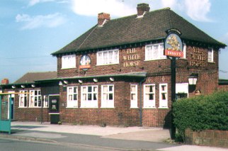 The White Horse, Whitehorse
Road.
The White Horse, Whitehorse
Road.
maps.google.co.uk pointer - 52.656986,
-1.937864
The original pub building on the site opened in 1861.
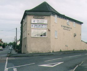 "Ye Olde Wilkin Inn" at
the corner of Wilkin Road and Hednesford Road. (Now a Thai
Restaurant). Was known as "The Monkey" in times gone by.
"Ye Olde Wilkin Inn" at
the corner of Wilkin Road and Hednesford Road. (Now a Thai
Restaurant). Was known as "The Monkey" in times gone by.
maps.google.co.uk pointer - 52.658974,
-1.950105
Web site --- http://thailanna.co.uk/thai-lanna-chasewater/
(Entry updated 1/10/2012)
The first mention of the pub was in the census of 1871 as "The Old Wilkin Inn".
"the Woodman" - see The Wheatsheaf.
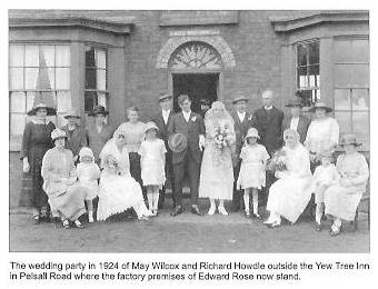 The Yew
Tree Inn pub was in Pelsall Road near the High Bridges.
The Yew
Tree Inn pub was in Pelsall Road near the High Bridges.
(photo on the left from
Memories of Old Brownhills by Clarice Mayo &
Geoff Harrington. Published in 2001)
V1.14 - 31 July 2015 ---- recommended resolution (1366 x 768)
© David Hodgkinson 2000-2015. All rights reserved.