Brownhills - Built on coal.
| This Madasafish site is no longer supported please visit the current site at http://www.thehodgkinsons.org.uk/brownhil.htm |
Brownhills - Gold Hoard capital of Britain
Brownhills - maker of Motor Racing Champions
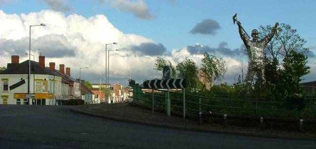
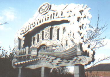
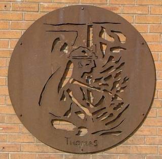
The Brownhills Miner (created by John McKenna of "a4a") and a view along the High Street
| The Public Houses of Brownhills | Local People & Writing | the Wyrley and Essington Canal | Books on Brownhills |
| Links | Back | Home |
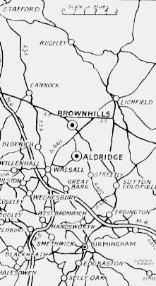 In the West Midlands of
England.
In the West Midlands of
England.
Knaves Castle tumulus was thought to be a Bronze Age burial mound. Described as "a small tumulus, inclosed within three ditches, the enterance is on the south side, it was hollowed on the top", it may well have been of Roman origin. (There is no longer any trace of the mound, it would have been on the south side of the Watling Street, between Deakin Avenue and the Wyrley and Essington Canal .)
The area was important as the Roman road from Dover to Wroxeter passed through the area - the Watling Street.
The hamlet of Ogley Hay, which over the years has merged into Brownhills, is much older. The name "Oogs's Leah" or Ocga Leah" was used in the Saxon era (meaning "Ooga's wood"). It was mentioned in A.D. 994 as belonging to Wolverhampton Monastery. The Doomsday Book of 1086 lists the area. During the 12th. century Ogley Hay may have become the property of Walsall's Lord of the Manor. Sir William Paget was given the lands by Henry VIII on the disolution of the monasteries.
The area of "Clayhanger" was mentioned in the lands of the Earl of Stafford in 1391.
The Robert Plot map of 1680 marks "Brownhill".
The Watling Street was vastly improved by Thomas Telford in the 18th. century to again become one of the country's main arteries.
At the time of the 1769 Yates' directory of the area, "Brownhills" was a collection of dwellings in the Pelsall Road / Clayhanger Lane area.
The population of Brownhills was 305 in 1841, coal mining being the main occupation.
The South Staffordshire Railway served "The Brown Hills" area from 1849.
Brownhills was only officially recognised when it became a "local government district" on 29th. September 1877.
Brownhills - Gold Hoard
capital of Britain
The "Staffordshire
Hoard" was discovered by amateur metal detector Terry
Herbert in a field belonging to a farmer Fred Johnson, near
Brownhills on the 5th July 2009. His find turned out to be the
largest Anglo-Saxon hoard of gold ever found in the country -
over 3,500 items in total - about 11lb of gold and 3 lb of silver.
The artefacts of the Mercian Kingdom of 7th or 8th Century were
declared treasure and so belong to The Crown. The hoard was
valued at £3.285 million. The value of the hoard was shared
between the finder and the landowner.
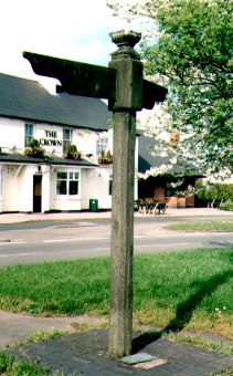
Civic Art - the soul of the town or money down the drain?
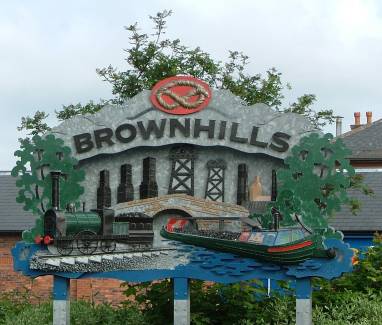 The Town sign at
the corner of the High Street and Silver Street was unveiled on
Wednesday 13/12/2000.
The Town sign at
the corner of the High Street and Silver Street was unveiled on
Wednesday 13/12/2000.
The galvanised steel fabrication was created by John McKenna of "a4a" - Art for Architecture. The public artist's design was arrived at after research with local people, Walsall Community Arts Team and the Environmental Inprovement Group.
Some of the less obvious symbols in the design are the hills
of Cannock Chase and the trees
of Cannock Chase and the trees for the long gone forests of
Walsall Wood.
On the left is the original plain finish (photo
taken 8/3/2001)
and
on the right is the updated
colour finish (photo taken 13/6/2008)
 |
 |
 |
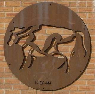
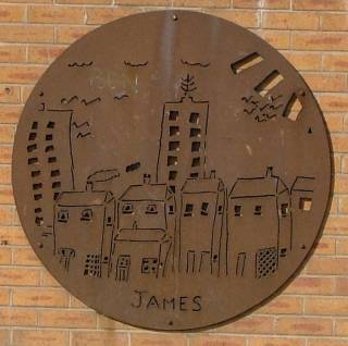
| Some more street art in the High Street opposite The Warreners Arms (that later became the now closed McDonald's burger bar). | 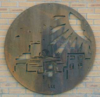 |
By Kieran, James and Thomas. (photos
above taken 30/6/2008). By Lee (photo taken 8/6/2001). But the plaque by Lee disappeared between 2001 and 2008 - anyone know why? |
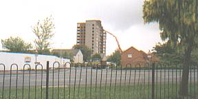 A block of
Brownhills flats have reached the end of the line - 2004!
A block of
Brownhills flats have reached the end of the line - 2004!
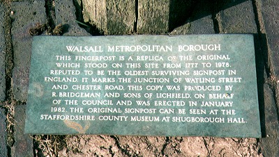
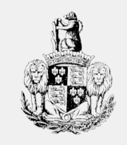 The
crest of Walsall Metropolitan Borough Council - which has covered the Brownhills area from 1974.
The
crest of Walsall Metropolitan Borough Council - which has covered the Brownhills area from 1974.
Including the legendary "Bear and Ragged Staff" and the "Stafford Knot".
It is reputed that an Earl of Warwick, "Morvid", battled against a giant bear armed with a club made from a torn up tree. A later Earl of Warwick, Richard, used the bear & staff as his emblem during his time as Lord of the Manor of Walsall.
|
 |
 Brownhills is situated on the edge of
the West Midlands conurbation and specifically the Black Country
industrial area. The town was built on coalmines, canals and
railways.
Brownhills is situated on the edge of
the West Midlands conurbation and specifically the Black Country
industrial area. The town was built on coalmines, canals and
railways.
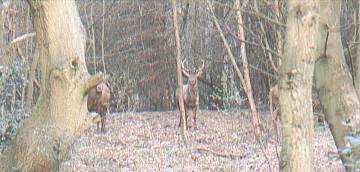
So why the picture of Elk in the wilds of Lapland? The photo was actually taken (25th March 2003) on Brownhills Common within a few yards of the A5 Watling Street main road. The Royal Forest of Cannock (or Cannock Chase) was formed over a 1000 years ago and at one time stretched over a wide area including what became Brownhills. One of the main functions of the Forest was to provide fresh food for "the ruling classes" and was stocked with deer. The Cannock Chase forest has shrunk to a small part of its earlier size but still supports a large population of deer. With the recent increases in tree planting and nature parks, deer are testing the limits of their habitat including Brownhills.
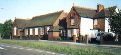
The old Brownhills "Central"
Boys School. At the junction of Pelsall
Road and the Chester Road. The building dating from 1893,
was designed for 210 boys & girls & 120 infants. Attended by both boys and girls untill 1932. It finally
closed in 1980 when it (and the Girls High School ) were replaced
by what is now called "Brownhills School" , which is
situated on the opposite side of Holland Park.
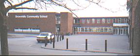
"Brownhills School"
or "Brownhills Community Technology College" or "Brownhills
Community School" (take your pick !)
from Brownhills Common and from the main entrance.
 Watling
Street Junior & Infants School - at
the junction of Watling Street (A5) and The Parade &
Whitehorse Road.
Watling
Street Junior & Infants School - at
the junction of Watling Street (A5) and The Parade &
Whitehorse Road.
The school was built in 1878, for 500 children. in 1901 the average attendance was 180 boys, 180 girls & 120 infants.
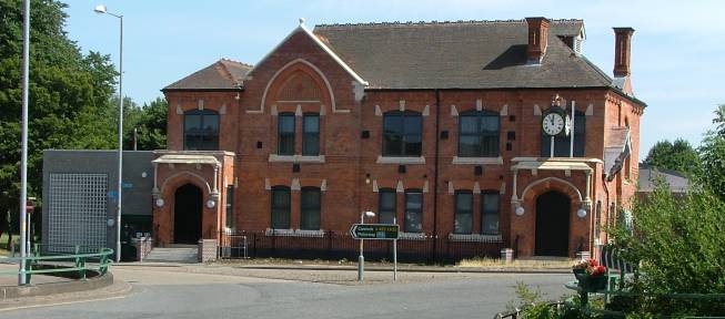
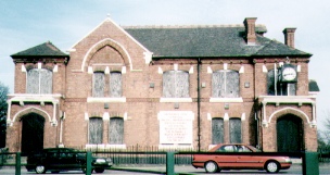
The Council House was built in 1882 and became the home of Brownhills Urban District Council which was formed in 1894. Situated on "the Bridge" at the junction of the Chester Road and Pelsall Road, it is well known for its clock.
The Park View Centre is the new title for the Council House which has become a "brand new state-of-the-art library and health centre run by Walsall Council and Walsall Teaching Primary Care Trust".
The photo on the left shows the building just reopened in 2006 - that on the right as it was waiting for renovation.
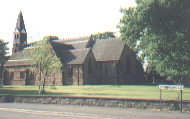
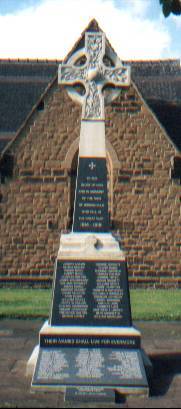 St. James' Anglican church and the War Memorial.
The church was completed in 1851 for a cost of £3,671.
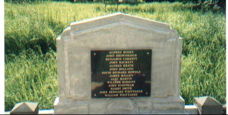 "ERECTED to the memory
of the fourteen men who lost their lives in the disaster which
occured at the GROVE PIT, NORTON CANES on the 1st. October 1930."
"ERECTED to the memory
of the fourteen men who lost their lives in the disaster which
occured at the GROVE PIT, NORTON CANES on the 1st. October 1930."
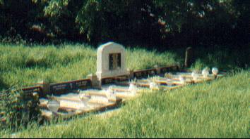
In St. James Church churchyard.
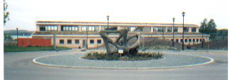
The new £1.9 million Rangers Office and Innovations Centre. The Forest of Mercia management are a major user of the centre.
The Park is a major centre of wildlife and water based leisure activities in it's 300 hectares.
The sculpture from 1962 is by Bryan Blumer(1925-1981) - not "Brian Bloomer" as previously stated.
Chasewater Wildlife Group record all the wildlife that is observed here with news of interest to local people as well as visiting birdwatchers and naturalists.
 "The Great Pool"
(or "Cannock Chase Reservoir", later "Norton Pool"
and now "Chasewater") was opened in 1799. Contains 800 million gallons of water. The lake still feeds the Wyrley and Essington Canal and
the wider canal network.
"The Great Pool"
(or "Cannock Chase Reservoir", later "Norton Pool"
and now "Chasewater") was opened in 1799. Contains 800 million gallons of water. The lake still feeds the Wyrley and Essington Canal and
the wider canal network.
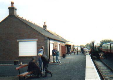 Chasewater Railway within Chasewater Country
Park. The new Brownhills West Station opened in 2001.
Chasewater Railway within Chasewater Country
Park. The new Brownhills West Station opened in 2001.
The line is open to passengers around the lake, across the causeway between Chasewater & Jeffrey's Swag and on to the Norton Lakeside Station and it's wildfowl reserve and then onto Chasewater Heaths Station. The next section to Chasetown (Church Street) Station should open in early 2004.
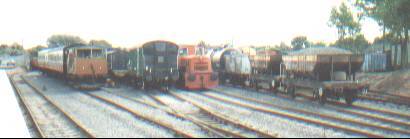 The line operates heritage passenger
& freight trains along the only remaining section of the
former Cannock Chase coalfield network using preserved steam and
diesel trains.
The line operates heritage passenger
& freight trains along the only remaining section of the
former Cannock Chase coalfield network using preserved steam and
diesel trains.
 Brownhills
- maker of Motor Racing Champions
Brownhills
- maker of Motor Racing Champions
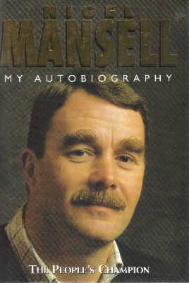
"All of my spare time and my school holidays were spent
working on my kart and racing it. I can remember putting the kart
in the boot of the car and going off to the little track at
Chasewater testing. My father and I used to make dozens of trips
like this. We would test engines and pistons and run bits in at
Chasewater, then go back home and rub the pistons down and hone
the barrels, then go back to the track to try it again. My father
and I were extremely close in those days and I think in a way he
was re-living his childhood through me, because he had a very bad
time in the Second World War."
Page 76 of "Nigel Mansell - My Autobiography (The People's
Champion)" by the 1992 Formula One World Champion
Chasewater
Kart Racing Club
"The Club was formed in 1959 and after a couple of years
moving around located to a former rolling skating area in the
Chasewater Park. ---- All this was good until the plans
for the M6 Toll (Birmingham Northern Relief Road) appeared in
1993. Unfortunately those plans put the motorway across part of
the track. ---- The last race was run in December 2000 and the
old track finally closed in May 2001. Forty years after it first
started.
We are searching for a site for a
kart circuit - Can you help? We want to develop a new sports venue
that will provide some of the best facilities available for kart
racing and which can be adopted by other sports and users in the
area."
.jpg) Clive
Roberts of snippets of local history has provided this |
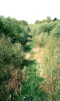 This
photograph, taken in 2000 from the same point beside the
old Council House, shows little of the past use of the
cutting into the sandstone hill. This
photograph, taken in 2000 from the same point beside the
old Council House, shows little of the past use of the
cutting into the sandstone hill. |
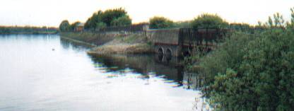
To the right of the Council House was Brownhills Railway Station. The line opened in 1849. Passenger operation stopped in 1965. The track on this section was lifted in 1984.
The South Staffordshire Railway ran for 23 miles from the
Great Western Railway (GWR) network at Dudley to Walsall (the
company headquarters) through Pelsall and then Brownhills and on
to Hammerwich, Lichfield and Wichnor Junction to meet the Midland
Railway Derby to Birmingham line.
Engineer John Robinson McClean was responsible for building the
line and was given a 21year lease on the line on completion. (Not
unlike the current BNRR (M6 Toll) motorway which will be operated
by it's builders!)
1849 - Opened to fare paying passengers on 1st
June (after an official opening on Easter Monday).
1853 - A spur to "Hammerwich" (Cannock
Chase Colliery no.1) & "Uxbridge" (Cannock Chase
Colliery no.2) was built from the Anglesey Sidings.
1858 - A pipeline from Lichfield to Walsall
alongside the track started to supply the industrial town with
pure country water.
1861 - London & North Western Railway took
over on 1st February.
1958 - Diesel service started. Park Royal diesel
multiple unit (DMU) being the standard.
1965 - Last day of passenger operation was
Saturday 16th January.
1984 - The line from Anglesey Sidings to
Ryecroft was closed to goods traffic on 19th March; the track has
since been lifted.
2001 - The end of the line? - The section of the
line south from Lichfield to Anglesey Sidings, Brownhills
continued in use to service the Charrington Fuel Distribution
Depot. John Boynton in "Rails Around Walsall" - (ISBN 0
9522248 3 6) said that trains in 1996 were expected on Tuesdays/Thursdays/Saturdays
(dependant in demand). The last oil train into the former
Charringtons and later B.P.oil depot was on the 17th
May 2001.
Ken Hubbard has given details of the end of active use of the line… “The last oil train into the former Charringtons and later B.P.oil depot was on the 17th May 2001. The last load of 25,000 litres of heavy fuel oil went out by road to British Sugar at Norwich on a cold wet Thursday morning on the 6th December 2001, I was the only person to witness this. It was a sad day for the once busy oil depot that opened in 1966 and once supplied oil for power stations and industry agriculture and domestic heating, as heavy fuel oil was the main product to be stored at Brownhills. Three trains a week arrived during the winter months. These trains would be unloaded from usually 35 rail wagons just over 1,000,000 litres per train, and the steam that was a familiar site up the siding on those days for any one travelling along the main A5 trunk road. The steam was used to heat up the heavy fuel oil and make it easier to discharge. The other oil products diesel kerosene and red diesel or gas oil as it is known as sometimes were all transferred to the B.P. main terminal at Kingsbury near Tamworth. The last load of medium fuel oil went out on the 27th March 2002 and the gates were finally closed on this local landmark on the 31st April 2002.”
The storage tanks have now gone but the rail line forms the border of the road transport yard that now occupies the site. At the junction of Watling Street (A5) and Ogley Hay Road/Chase Road.
Reporting on the last Burton - Brownhills - Walsall train the
Express & Star of Wolverhampton said, "Will the
passenger service ever re-open? If the answer depends on
economics, No. Receipts, as Dr. Beeching would say, were nowhere
meeting the 'true costs'. The last train down took 31 minutes
without being pressed. It is scarcely a tribute to transport
progress that the alternative express road buses will take 52
minutes."
Brownhills(Midland Railway) Station, (called Brownhills
Watling Street Station from 1924) was situated on the Chester
Road a little way North of the Hussey Arms pub. An abutment of
the bridge over the main road and some minor brickwork hidden
within the Common is all that remain.
1879 - The Midland Railway route from Birmingham to Wolverhampton
via Walsall was opened. To provide access to the coalfields in
the Chasewater area a branch line of about five miles was planned
from the "Sutton Park Line" at Aldridge.
1882 - The branch line serving Brownhills coal mines opened to
goods in November 1882.
1884 - Passenger services started between Aldridge, Walsall Wood
and Brownhills.
1930 - Passenger services were withdrawn in March 1930.
1962 - Goods services finally withdrawn with the closure of the
pits and the line closed.
1970 - Chasewater Light Railway started passenger services on
their preserved section of the line.
2001 - Chasewater Railway opened their new station after an
enforced move a little way around the lake to make way for the
BNRR (M6 Toll) motorway.
V1.23 - 20 November 2012 ---- recommended resolution (1366 x 768)
© David Hodgkinson 2000-2012. All rights reserved.