 Image
produced from the Ordnance Survey Get-a-map service. Image
reproduced with kind permission of Ordnance
Survey and Multi Media Mapping.
Image
produced from the Ordnance Survey Get-a-map service. Image
reproduced with kind permission of Ordnance
Survey and Multi Media Mapping. The Wyrley and Essington Canal
| This Madasafish site is no longer supported please visit the current site at http://www.thehodgkinsons.org.uk/wyrley.htm |
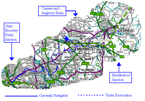
| Virtual Walks | 1 - Anglesey Basin at Chasewater to Ogley Junction (or Anglesey Junction) |
| Too far away to visit? | 2 - Ogley Junction (or Anglesey Junction) to Catshill Junction |
| Don't want to go out today? | 3 - Catshill Junction to Pelsall Junction |
| I've done it for you. | 4 - Catshill Junction to Walsall Wood |
| Try these walks .......... | 5 - Ogley Junction (or Anglesey Junction) to Huddlesford Junction |
| 6 - The Cannock Extension from Pelsall Junction | |
7 - Pelsall Junction to Lord Hayes Branch and Onward along the Hatherton Canal (under restoration) to its Junction of the Staffordshire and Worcestershire Canal |
Image
produced from the Ordnance Survey Get-a-map service. Image
reproduced with kind permission of Ordnance
Survey and Multi Media Mapping.
Wyrley and Essington Canal - 1792. First act of parliament to build between "Essington Bank" and "Wyrley Bank".
Wyrley and Essington Canal - 1794. Further act of parliament to build through to the Coventry Canal at Huddlesford. Lichfield Canal extension - 1797. Link to the Coventry Canal at Huddlesford was opened. Its seven miles contained 30 locks.
Cannock Chase Reservoir (Chasewater) - 1799. Contains 800 million gallons of water. Dam burst - in June 1799 floodwater from the Reservoir left a trail of destruction south east to Tamworth and the River Tame beyond. The flood was caused by the failure of a sluice gate at the dam.
Anglesey Branch Canal - 1850. Was built along the line of the feeder from the Cannock Chase Reservoir to connect with the W & E. Anglesey Basin was required to carry coal from mines of the area.
Lichfield Canal extension - 1954. Closed (and later drained).
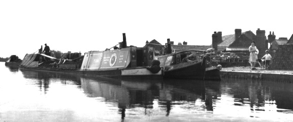 |
Brownhills canal view of the 1950's while the route was still in commercial use. |
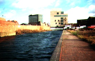 Walsall's
new art gallery at the end of the Walsall's
new art gallery at the end of the Walsall Extention of the W&E |
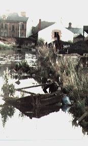 ...and
the state of the canal ...and
the state of the canal a few years previous. |
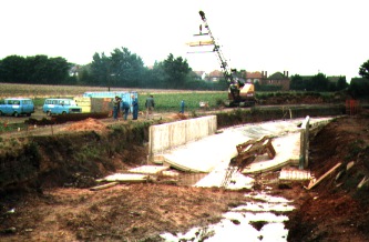
 The
scale of work needed The
scale of work neededto bring a lock back to life. |
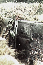
 The
efforts needed to plug a hole in the bottom The
efforts needed to plug a hole in the bottom of a stretch of canal. Just north of the Anchor
Bridge, Brownhills. |
| --------------------------------- Sources and Links to other Canal interest sites------------------------------- |
Birmingham Canal Navigation Society
British Waterways Home Page "On 2 July 2012, British Waterways ceased to exist in England and Wales and in its place Canal & River Trust was set up to care for 2,000 miles of historic waterways."
Brownhills Canoe and Outdoor Centre The Club state ... "We officially
opened our doors in June 2006 during the Brownhills Canal
Festival
The Centre was built with funding from Active England (a joint
funding programme between Sport England and the Big Lottery Fund),
the European Regional Development Fund and British Waterways.
Our aim is..'to provide a venue for the community of Brownhills
and the surrounding areas to take part in the sport of canoeing
and other outdoor recreational pursuits' "
Canal & River Trust "We’re the new charity entrusted with the care of 2,000 miles of waterways in England and Wales."
LAURENCE
HOGG PRODUCTIONS The maker of the Video BCN 10
"The Missing Links".
"Today, the Northern waters of the BCN are only
accessible from the South, making the number of craft penetrating
the top of the BCN system quite small. The situation was not
always thus. The BCN has lost three major links in the course of
time: the Lapal Section of the Dudley Canal to the South, the
Hatherton Branch, Churchbridge Locks connection to the North West,
and the Lichfield part of the Wyrley and Essington Canal to the
North East. This film deals with these two lost links to the
North.... David Suchet introduces the film and then takes you on
a tour of the routes. We look back at the history and examine in
detail all of the sections including the parts which are lost for
ever..........."
Lichfield & Hatherton Canals Restoration Trust was formed in 1988 and is a registered charity. It campaigns for the restoration of the "Lichfield Canal" (as the closed section of the W&E between Ogley and Huddlesford is now called) and also the Hatherton Canal through the Cannock / A5 area. It promotes the restoration as public amenities for boating, angling, walking, cycling etc. and raises funds to carry out physical restoration work.
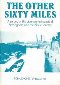 "The Other Sixty Miles - A survey of the abandoned
canals of Birmingham and the Black Country" by Richard
Chester-Browne - BCN Society 1981 & 1991
"The Other Sixty Miles - A survey of the abandoned
canals of Birmingham and the Black Country" by Richard
Chester-Browne - BCN Society 1981 & 1991
"THE OTHER SIXTY MILES
A survey of the Abandoned Canals of Birmingham and the Black
Country by R Chester-Browne
This book is based on the result of a survey of the abandoned
canals of Birmingham and the Black Country that I carried. out
during my years as a student in 1974-7, with some later
amendments. It does not set out to be a full history of the
abandoned branches, though I have included a certain amount of
historical and other information of general interest to set the
remains in perspective. Further information can be obtained from
some of the books listed in the bibliography. Destruction of the
remains of these canals is continually taking place, and the BCN
Society and I would be pleased to receive details of any changes
and / or corrections to the book. In the years since the first
edition of this book was published,
the loss to navigation of the Anson Branch has been counteracted
by the restoration of the Ridgacre Branch. Hopefully in the next
few years, the long term stoppages at Dudley Tunnel and Walsall
Wharf will be concluded and these waterways will not need to be
added to the next edition. Schemes are also underway, or have
been proposed, to restore the Hatherton Branch, the Wyrley &
Essington, Bradley Locks and, more optimistically, the Dudley No.2
Canal. The photographs in this book are my own, with the
exception of that on the back cover by Kelvin Lake. My good
friend Marcus Boudier, who drew the maps for this
book died in a boating accident in 1986. I would like to dedicate
this edition to his memory. R. Chester-Browne. Culcheth,
Cheshire Iuly 1991"
V1.13 - 21 October 2015 ---- recommended resolution (1366 x 768)
© David Hodgkinson 2000-2015. All rights reserved.