In the beginning………
In August 1972, planning permission was granted on
an application submitted by Total Oil for erection of a Self-service Petrol
Filling Station on ground that currently included an entrance drive from
Marsland Road to the rear of the Brooklands Hotel, which was situated on the
corner of the junction of Marsland Road and Hope Road. Planning permission was
also granted (presumably contemporaneously) for the erection of a large office
block on the actual site of the Brooklands Hotel.
The Brooklands Hotel was originally built in 1872
and amongst its claims to fame was that it was the site of the signing of the
first agreement between capital and labour in the cotton industry. The document
signed in 1893 between employer and employee was called the Brooklands
Agreement.
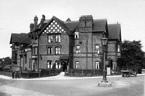
Brooklands Hotel,
1925
In 1926 it was realised that unless Manchester had
a permanent airport the city would suffer commercially, and city officials
lobbied for the establishment of a permanent airport. While Barton, five miles
west of the city, was chosen as the site for the new airport, it had a number of
problems and it was deemed to be unsuitable for larger aircraft. A new site
found was south west of the city and construction of the new airfield, Ringway,
began in 1934. The Brooklands Hotel had obviously already gained an enviable
reputation for comfort and quality, demonstrated by the fact that now (and for
many years to come) it would reputedly become THE ‘airport hotel’ for those
travelling to Manchester by air, despite its distance from Ringway Airport.
Laurel and Hardy were also famous visitors –
during their visit to Bolton in September 1947 (at the Lido Cinema/Theatre), and
although they could have stayed in a Bolton hotel (or even at the Midland Hotel in Manchester, which they
seemed to like), they stayed at the Brooklands Hotel.
Sadly, as time went by and other hotels were
eventually built closer to the airport, the use of the hotel as such diminished,
although it remained extremely popular for functions and as a public house.
However, once again, this remaining business was further diminished following
the building of the ‘Little B’ less than a couple of hundred yards along
Marsland Road, and the ‘Brooklands Tap’ right next door on Hope Road. These
two pubs, designed and built for this purpose, sounded the death-knell for the
Brooklands Hotel, as its size rendered it totally uneconomic. As a result, the
hotel finally ceased trading and, together with the land it stood on, was put up
for sale. Unfortunately, probably at that time no other purpose or type of use
was envisaged or would have been permitted, and no purchaser prepared to
continue its usage appeared. For one reason or another, attempts to have the
building afforded listed or protected status came to naught (unlike the Sale
Hotel nearly forty years later!). As a result, the site fell into the hands of
those who would completely “redevelop” the site.
Once planning permission was granted, in due course
workers arrived with equipment to demolish the hotel, in preparation for the
‘redevelopment’ of the whole site.
The “equipment” consisted of a small bulldozer,
brought on a flatbed lorry – without any ramps or other method of off-loading
the bulldozer. Following a couple of attempts to drive this off the lorry
(nearly resulting in a nose-dive), the lorry was repositioned across
Marsland Road with its tail against the raised banking (about five feet high) at
the side of the hotel – a nice hold-up of traffic ensued….. The bulldozer
was then driven onto the bank, which then left the problem of any further
movement. Eventually, inspiration struck and it was decided to drive the
bulldozer from the banking straight to the car park behind the hotel – down a
45 degree (or steeper?) slope….. A forward somersault was avoided, but only by
travelling part way down in a (definitely unplanned) sideways slide…..
When once again down on (more or less) level
ground, it was no doubt considered that demolition could commence with few (if
any) further problems. However, after several assaults were attempted using the
bulldozer blade on different areas of the walls, which did remove a few bricks
here and there, it was finally decided that a more effective method would be to
attach one end of a chain to the bulldozer, run it through (widely) separated
windows, re-attach the chain to the bulldozer and pull… Not quite that
easy….. adjacent windows only! Two of the most notable side-effects of this
method were that as each section was pulled out, large portions of both ground
and upper floor walls collapsed, throwing out chunks and individual bricks some
distance – including across the full width of Marsland Road! This, together
with the associated thick clouds of dust, created somewhat of a hazard to
anything and anybody intending to travel along Marsland Road – naturally, this
then of course required a couple of the demolition men to dash out into the
road, hold back the traffic as the walls fell, then hastily clear rubble off the
road before waving traffic and pedestrians on their way once more. Fortunately,
none of the neighbouring houses were struck by flying brickwork, although every
house was still finding and clearing dust for some considerable while later.
Sadly, despite numerous incidents worthy of classic
slapstick movies, the whole building was razed to the ground. From this point
onwards, no “lighter moments” exist to be documented. While the planning
permission stated that “No tree shall be felled without prior consent of the
Local Planning Authority….”, several trees were felled – with consent or
not? Who knows…
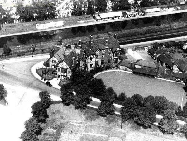
Aerial view, 1925
Excavation and removal of earth etc. for
foundations and underground parking area for the multi-story office block
commenced, together with excavation for installation of petrol storage tanks –
none of this excavated soil (and rubble from the demolished hotel) was
removed – merely redistributed over the area of the original car park and
entrance thereto, with concrete then laid on top. The result of this is that the
ground level of the south-west part of the site was drastically raised. Until
this time, this whole area of land – bounded by the rear of the hotel, the
private residences on Glenthorn Grove, and the private residence of 228 Marsland
Road – was on average two feet lower than all these properties – the site
ground level was now approximately two feet higher than that of the
neighbouring properties! All the local residents from that time (and also local
councillors, past and present!) clearly remember that the entrance drive to the
hotel car park dropped down from Marsland Road – this entrance being at
the present petrol station’s exit, next to 228 Marsland Road (just
off-picture, lower right). The aerial view from 1925 shows the bowling green and
clubhouse, long gone by the ‘60’s and ‘70’s, but still clearly showing
the much lower ground level in that area. The area occupied by the clubhouse and
smaller buildings to the centre-right, is now occupied by the Brooklands Tap on
Hope Road and its associated car park. An indication of the ground level prior
to demolition is demonstrated by that of the small park on the other side of
Marsland Road, which was the same level and so exists to this day.
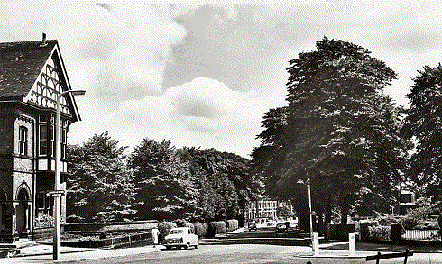
Marsland Road,
1967
The 1967 view of Marsland Road clearly shows how
the road drops down past the hotel, and the car at the bottom of the hill is
just about at the entrance to the hotel grounds. (The mini-bulldozer was
decanted onto the raised bank just next to the nearest car..). The abundant
array of mature, long-established trees is also very evident. These bounded the
entrance driveway and natural landscaping, while a mixed privet and holly hedge
formed the boundary to Glenthorn Grove. For those of us who lived there around
that period, no better view or aspect could be desired – over our boundary
hedge, a wide and long uncultivated but maintained area of ground with beautiful
trees on the further side, far enough to block no light or sky, with (to the far
right) a beautiful and stately building – which at night, showed lights softly
shining through (in parts) stained glass windows… How I regret not having pictures of that happy time…..
The petrol station (with attached shop) duly opened
in accordance with the conditions imposed in the planning permission, i.e. from
7.00am to 11.00pm, with the shop selling only items “directly connected to the
motor trade.” However, within a relatively short time, it became common
practice for cars to park during the day, and one or two heavy goods vehicles
(and also the odd car) to park up overnight – always nearest the houses -
followed by starting and warming up of engine from (very) early morning. While
complaints to both garage staff and Total head office eventually stopped the
heavy goods vehicles, cars continued to park for a much longer time.
Additionally, despite complaints, children and youths were allowed to “play”
all over the site, which frequently involved the throwing of rubbish and stones
into our gardens and at our windows. Apart from the goods vehicles, the other
problems continued on and off for a few years, and were referred to in my
objections to the first few planning applications….
Next
page